Geospatial Integrity expectations for Equinor's OSDU
- This section clarifies the geospatial data integrity requirements in Equinor's OSDU environment.
- The intended audience for this section includes all stakeholders involved in providing and using geospatial data in Equinor's OSDU environment. The aim is to ensure that all parties understand and adhere to the requirements, thereby maintaining geospatial data integrity.
- This section aims to align OSDU guidelines with our internal, Equinor geospatial integrity requirements and recommendations, and to strengthen the robustness of our geospatial data practices within OSDU. Geospatial integrity principles for OSDU have been considered, along with the discrepancies between the current OSDU (requirements, guidelines, implementations) and our internal expectations. The aim is to align with the OSDU forum as well as to influence whenever necessary.
- Information in this section will be updated regularly as needed, along with relevant follow-up communication.
Metadata of geospatial data
Requirement
Position data and position metadata (together with other metadata) to be ingested into Equinor's OSDU environments shall consistently be retained together while exchanging.
- This means that coordinates representing positions should always be exchanged together with the propoer Coordinate Reference System (CRS).
- Following the ingestion of data into Equinor's OSDU environments, any enrichment or derivation of position data, along with relevant metadata, must be thoroughly documented.
Geospatial data with Equinor CRS/CT
Requirement
Coordinates representing geospatial data ingested into Equinor OSDU shall have Equinor CRS/CT Reference Data assigned.
Equinor geodetic parameters - Equinor CRS/CT Reference Data - in Equinor's OSDU environments is ensured by Equinor Geodetic Repository (EGR) and Equinor Geodetic Engine (EGE). This is to ensure the exchange of geospatial data with relevant interfaces and interoperability.
Equinor's CRS distribution (to geoApps and) OSDU
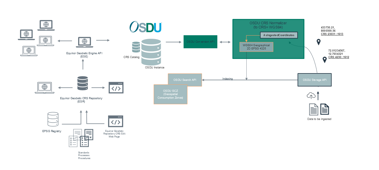
For ingested geospatial data into Equinor's OSDU environments, the following needs to be ensured:
- For non-WGS84 based CRS, a BoundCRS shall be associated with ingested data in OSDU
- The "CoordinateReferenceSystemID" property shall be populated for the geospatial data ingested into Equinor OSDU
- The "persistableReferenceCrs" property shall stay as an empty string (this string is mandatory in OSDU)
- Note: Long-term GI governance goal: "persistableReferenceCrs" string is not required at all, only "CoordinateReferenceSystemID" is required! (pic. below)
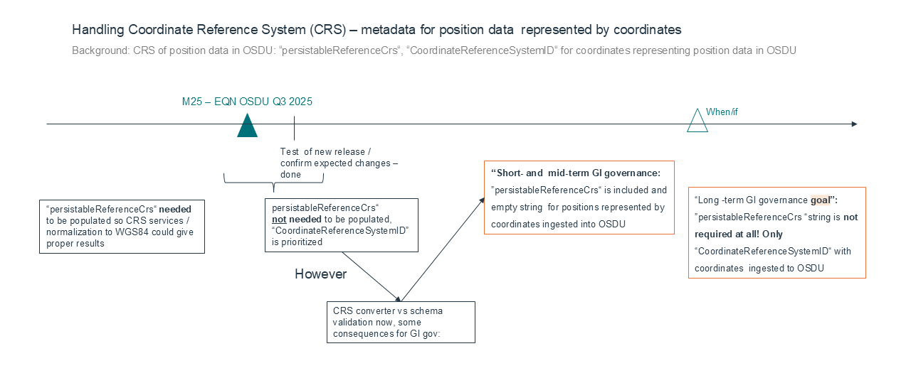
Before M25 (Equinor):
"AsIngestedCoordinates": {
        "type": "AnyCrsFeatureCollection",
        "CoordinateReferenceSystemID": "data:reference-data--CoordinateReferenceSystem:BoundGeographic2D:EPSG::4230_EPSG::1612:",
        "persistableReferenceCrs": "{\"authCode\":{\"auth\":\"Equinor\",\"code\":\"1100099\"},\"lateBoundCRS\":{\"authCode\":{\"auth\":\"EPSG\",\"code\":\"4230\"},\"name\":\"ST_ED50_G4230\",\"type\":\"LBC\",\"ver\":\"PE_10_9_1\",\"wkt\":\"GEOGCS[\\\"GCS_European_1950\\\",DATUM[\\\"D_European_1950\\\",SPHEROID[\\\"International_1924\\\",6378388.0,297.0]],PRIMEM[\\\"Greenwich\\\",0.0],UNIT[\\\"Degree\\\",0.0174532925199433],AUTHORITY[\\\"EPSG\\\",4230]]\"},\"name\":\"ST_ED50_T1133\",\"singleCT\":{\"authCode\":{\"auth\":\"EPSG\",\"code\":\"1133\"},\"name\":\"ST_ED50_WGS84_T1133\",\"type\":\"ST\",\"ver\":\"PE_10_9_1\",\"wkt\":\"GEOGTRAN[\\\"ED_1950_To_WGS_1984_1\\\",GEOGCS[\\\"GCS_European_1950\\\",DATUM[\\\"D_European_1950\\\",SPHEROID[\\\"International_1924\\\",6378388.0,297.0]],PRIMEM[\\\"Greenwich\\\",0.0],UNIT[\\\"Degree\\\",0.0174532925199433]],GEOGCS[\\\"GCS_WGS_1984\\\",DATUM[\\\"D_WGS_1984\\\",SPHEROID[\\\"WGS_1984\\\",6378137.0,298.257223563]],PRIMEM[\\\"Greenwich\\\",0.0],UNIT[\\\"Degree\\\",0.0174532925199433]],METHOD[\\\"Geocentric_Translation\\\"],PARAMETER[\\\"X_Axis_Translation\\\",-87],PARAMETER[\\\"Y_Axis_Translation\\\",-98],PARAMETER[\\\"Z_Axis_Translation\\\",-121],OPERATIONACCURACY[10],AUTHORITY[\\\"EPSG\\\",1133]]\"},\"type\":\"EBC\",\"ver\":\"PE_10_9_1\"}",
        "features": [
          {
            "type": "AnyCrsFeature",
            "geometry": {
              "type": "AnyCrsPoint",
              "coordinates": [
                4.5000000,
                59.000000
M25 (Equinor):
"AsIngestedCoordinates": {
        "type": "AnyCrsFeatureCollection",
        "CoordinateReferenceSystemID": "data:reference-data--CoordinateReferenceSystem:BoundGeographic2D:EPSG::4230_EPSG::1133:",
        "persistableReferenceCrs": "",
        "features": [
          {
            "type": "AnyCrsFeature",
            "geometry": {
              "type": "AnyCrsPoint",
              "coordinates": [
                4.5000000,
                59.000000
Long term Equinor GI goal:
"AsIngestedCoordinates": {
        "type": "AnyCrsFeatureCollection",
        "CoordinateReferenceSystemID": "data:reference-data--CoordinateReferenceSystem:BoundGeographic2D:EPSG::4230_EPSG::1133:",
        "features": [
          {
            "type": "AnyCrsFeature",
            "geometry": {
              "type": "AnyCrsPoint",
              "coordinates": [
                4.5000000,
                59.000000
Geospatial data represented by coordinates
Requirement
Geospatial data represented by original coordinates shall be retained in Equinor's OSDU environment.
- Original coordinates should be retained in Equinor OSDU using the "AsIngestedCoordinates" block in OSDU (including coordinates in WGS84)
- WGS84Coordinates block should not be used for ingesting coordinates
Audit trail
Requirement
Audit trail of coordinates representing position data shall be achieved in Equinor's OSDU environment. Audit trail should be visible.
- Audit trail of coordinates representing position data from the original state to the current state shall be achieved in Equinor's OSDU environment.
- All coordinates shall be ingested into Equinor's OSDU environment into the "AsIngestedCoordinates" block.
- The WGS 84 coordinates (WGS 84 geographical coordinates) shall be resulting from proper coordinate operations, performed by the OSDU normalizer and automatically populated into the OSDU Search "Wgs84Coordinates" block during ingestion.
- In case WGS 84 (geographical coordinates) are to be ingested into Equinor's OSDU environment from source, these shall be populated into the "AsIngestedCoordinates" block with proper CRS tagging. In this way the proper audit trail can be achieved.